The Center for Archaeological Science, Sichuan University, in collaboration with multiple international institutions, is constructing a strontium isotope map of Africa to trace the geographical origins of victims of the transatlantic slave trade.
Population migration has played a significant role in the development of human civilization, shaping global ethnic and cultural patterns. The transatlantic slave trade from the 15th to 19th centuries was the largest forced migration event in global history, trafficking at least 15 million Africans to the Americas and Europe, profoundly altering the ethnic structures and political landscapes of Africa, the Americas, and Europe today. Despite extensive historical documents recording the scale of the slave trade and port information, the geographical origins and life experiences of enslaved individuals have been difficult to ascertain, a long-standing challenge for global archaeologists and historians.
Strontium isotope analysis (87Sr/86Sr) is an important tool for tracking human migration, and its use promises to solve this historical problem. Existing research has identified multiple individuals with high strontium isotope ratios different from local values in slave-related archaeological sites in the Americas. However, due to long-term social unrest in Central and West Africa, harsh field working conditions, and a lack of isotope analysis instruments, strontium isotope baseline data for the African continent are severely lacking, limiting the ability of existing research to accurately define the origins of foreign individuals.
Recently, Xueye Wang, a specially appointed associate research fellow at the Center for Archaeological Science, Sichuan University, in collaboration with 112 international collaborators, published a research paper titled 鈥淪trontium isoscape of sub-Saharan Africa allows tracing origins of victims of the transatlantic slave trade鈥� in the international comprehensive journal Nature Communications. Associate Research Fellow Wang Xueye is the first author, and Associate Professor Vicky M. Oelze of the University of California, Santa Cruz, is the corresponding author. The Center for Archaeological Science, Sichuan University is the first author's affiliation, and collaborating institutions include the Max Planck Institute for Evolutionary Anthropology, Harvard University, Oxford University, and University College London, among 61 internationally renowned research institutions.

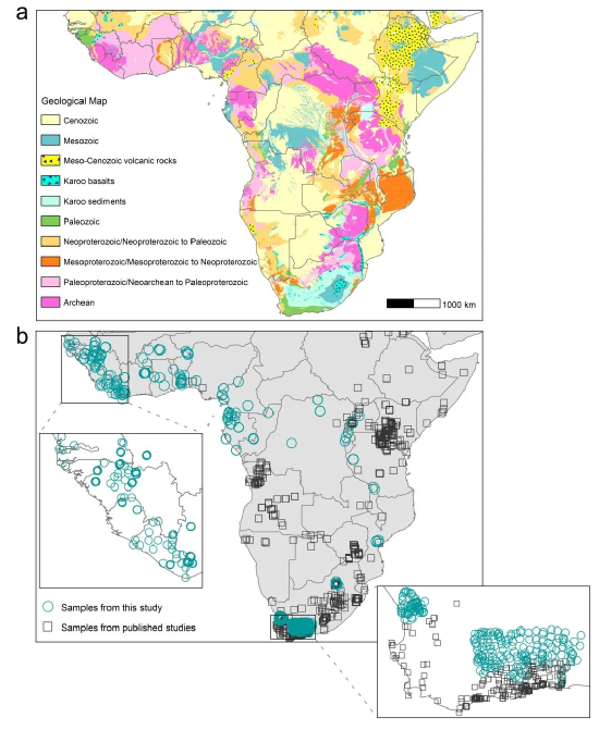
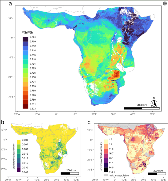
This study collected and analyzed 778 environmental samples (including plants, soil leachates, and microfauna) from 24 African countries, focusing on data-scarce West and Central-West Africa, with strontium isotope data from 16 countries reported for the first time (Figure 1b). The research team combined 2266 published data points, integrated 31 geological and environmental variables, and successfully constructed a high-precision bioavailable strontium isotope baseline map of Africa (Figure 2a) using a random forest regression algorithm. The results showed that the main factors affecting the spatial distribution of strontium isotopes in Africa include atmospheric deposition, land age, and sediment clay content. Previous studies have not fully considered the unreliability that may exist when random forest models extrapolate beyond areas lacking matching training data. This study introduced a multivariate Mahalanobis distance map to eliminate areas outside the range of environmental variables (Figure 2c), significantly improving the reliability of the mapping results.
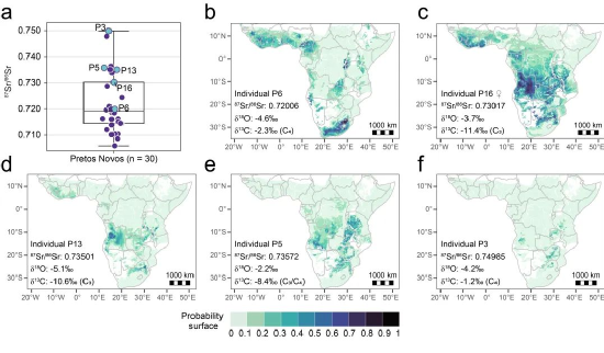
This study further applied the constructed strontium isotope map to two important burial sites related to the slave trade: the Anson Street African Burial Ground in Charleston, USA, and the Pretos Novos Cemetery in Rio de Janeiro, Brazil. By combining strontium, carbon, and oxygen isotope data, ancient DNA, and historical documents, this study significantly narrowed the range of origins for these individuals. For example, the origin of some individuals with high strontium isotope values (87Sr/86Sr > 0.730) in the Pretos Novos Cemetery in Rio de Janeiro can be precisely located to the Angola region (Figure 3). This study demonstrates the great potential of combining strontium isotopes with multidisciplinary evidence to trace the geographic origins of individuals in complex historical contexts.
This study not only provides critical support for archaeological research on the transatlantic slave trade but also opens up new technical pathways for provenance research in African archaeology, ecology, and forensics. In ecology, the map can be used to track the habitat origins of endangered species (such as elephants and chimpanzees), assisting in the fight against illegal poaching and trade. In forensics, it provides an important tool for identifying African migrants or other unknown remains. In addition, strontium isotope analysis, combined with multi-isotope analysis, can also help identify the thousands of Mediterranean migrant fatalities each year (considered the largest humanitarian disaster in Europe since World War II), providing a scientific basis for respecting and upholding fundamental human rights.
Since its establishment, the Center for Archaeological Science, Sichuan University, has engaged in in-depth collaboration with well-known research institutions in many countries, and the significant research results achieved demonstrate the outstanding effectiveness of interdisciplinary and international collaboration. This study significantly improves the ability to identify the geographical origins of slaves buried outside Africa, helping more victims trace their possible African ancestral lands, thereby revealing critical information about their personal identities and heritage. At the same time, this research aims to encourage more and more researchers to pay attention to the identities and cultures of 鈥済roups without history鈥� during the colonial period, which has profound historical and cultural value.

Figure 1 (a) Geological map of sub-Saharan Africa; (b) Environmental sample collection points

Figure 2 (a) Machine learning algorithm simulates the bioavailable strontium isotope baseline map of sub-Saharan Africa; (b) Standard error map of simulation prediction; (c) Multivariate Mahalanobis distance map

Figure 3 Probability map of multi-isotope normalized geographic origin of five slave individuals from the Pretos Novos Cemetery in Rio de Janeiro, Brazil
